


3 hikes to take you away from it all
stories by Laurie Stephens
photography by Doug Burlock
Southern Georgian Bay is a hiker’s paradise. From challenging climbs up the Niagara Escarpment to leisurely strolls alongside local rivers, the variety of terrain, unique geological features and diversity of flora and fauna provide overwhelming choice for hikers of all abilities.
My mission: hike three trails, with friends, in three beautiful parts of region, all touching sections of the historic Bruce Trail. I put out the call to my hiking buddies. They’re up for the challenge.


Singhampton Caves Trail
Blue Mountains Section of the Bruce Trail
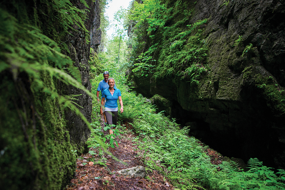
We are standing in the middle of a deep pit, looking up at massive granite walls that rise 30 feet high and envelop us on all four sides. Slivers of sun peek through the tree canopy above. It’s a feast for the senses.
The first sensation as we climb down into the crevice is heavy, cool moisture that is visible to the eye and clings to our skin. Then a sweet, earthy smell fills our nostrils, and as we glance up and around, we see the walls are alive, carpeted by all kinds of mosses and ferns. We hear the muffled sound of birds twittering above us.
This is the deepest part of the Singhampton Caves, a geological marvel that was formed millions of years ago when huge blocks of rock broke away from the cliff face of the Niagara Escarpment. Getting to this deepest crevice is not for the faint of heart. It involves carefully clambering down through narrow fissures in the rock, descending in stages through ‘crevice caves’ that each reveal a new wonder.
I’ve brought hiking poles with me on this hike and it’s a mistake. They become a hindrance when the descent requires both hands – and sometimes my rear-end – to make sure I don’t lose my footing on rocks that are still a bit slick from recent rain. The effort to manoeuvre through the rock formations has me breaking out in a sweat, even though the air is cool from moisture.
The six members of our group today are ski friends, many of us retirees, who are looking forward to exploring a new part of the Bruce Trail. This hiking trail, appropriately called the Singhampton Caves Trail, is in my opinion the most memorable of our three hikes, even though it is the shortest at only 2.3 kilometres.
The trek starts at the top of the Escarpment. After taking in a spectacular view of the Pretty River Valley from a lookout, the descent through the crevices is filled with sights that confound us, like huge birch and fir trees that sprout out of the rock walls and rise upwards to catch some sunrays. A large turkey vulture circles above us, no doubt hoping we are his lunch.
Our group takes it all in, searching for superlatives to describe this section of the trail with its interlocking crevices that take us deeper and deeper into the earth.
“It’s a mini Grand Canyon,” says Dave Nieuwold, a retired firefighter from Guelph. Or like something out of Jurassic Park, adds Katia Abaimova, a broker with a Collingwood real estate firm.
Deb Bloom Hall, from Collingwood, likens the rock structures to a giant Jenga set, while Karen Hall, a retiree from Wasaga Beach, marvels at the way the light hits the moss on the rock walls: “It looks like velvet.” Barry Zimmermann, Karen’s partner, is impressed by the way a large birch clings to the rockface: “Just look at that one root – it loops up the rock and then goes back down into a crack.”
We linger in the deepest crevice for a few minutes, soaking up the experience before beginning the much-easier climb out into a full deciduous forest. We start to ascend the Escarpment, and the odd mosquito buzzes us as we walk through a section that looks like a graveyard of white birch trees.
The upward trek is short but provides a burst of cardio before we reach the end of the trail where our cars are parked. It’s been an hour and a half, but too soon, this hike is done.


.")
Pretty River and Bruce Trail Loop
Blue Mountains Section of the Bruce Trail
It’s just after 3 p.m. and the temperature is only 24 degrees, but the humidity is fierce. I’ve got a good sweat going, and we’ve barely started our hike. But we’re in the forest and walking alongside the Pretty River – really a stream at this point –which burbles over rocks and provides a cooling mist that hangs in the air.
Our group, seven in number this time and all appropriately physically distancing in this COVID world, scramble over this early section of the trail where the stream encroaches the path in a couple of sections. Not everyone’s hiking boots remain dry.
For Morag Nieuwold, a retired teacher, this is her favourite part of the hike: “I love hearing the babbling brook and the rocks and the waterfalls.”
Morag and Dave Nieuwold began hiking when they first met 36 years ago. Both loved the outdoors and would incorporate hikes into their frequent camping trips. After they had children, they started hiking much more, to show their kids the beauty and splendour of Ontario’s great outdoors.
“It’s good to get away from the hustle and bustle of the city,” says Dave.
The allure of hiking extends beyond the simple enjoyment of nature. The physicality of an activity that takes place in what Bloom Hall calls “the centre of the universe” has other benefits as well: “It’s a chance to re-centre myself, and you don’t even realize it’s a workout, do you?”
A little over a kilometre in, we veer away from the river and start a slow climb through a forest of tall deciduous trees that allow slivers of sunlight to feed the lush undergrowth. The smell here is different – fresher and less moist.
Woodpeckers drum and cardinals sing to us as we follow a path that is well-worn and a little muddy in places on this day. A number of side trails criss-cross the main trail, and we take care to follow the signs and our map so that we don’t get sidetracked.
It’s an easy climb at first – not technical – with surprisingly few bugs. But then we start the serious ascent up terrain that is much steeper. I put my head down and climb, my heartrate rising and sweat dripping down my face and body. We finally reach the lookout at the top – our Garmin watches tell us we’ve climbed almost 300 metres – and we peek through the trees for a view of the Pretty River Valley. It’s a gorgeous vista of tracts of golden farmers’ fields carved out of deep green forests. A barn with a bright red roof punctuates the scene.
A conversation ensues. Do we hike the other loop to make it the full nine-kilometre Pretty River/Bruce Trail experience, or do we start back and head to Side Launch Brewing Company in nearby Collingwood for a beer? A quick check of the brewery’s closing time seals the deal.
If we want to make it there before 6 p.m., we have to hustle, so we retrace our steps down the main trail and then veer off onto a side trail that takes us past one last point of beauty, a small pond that glistens in the full sun. We pause briefly to take it in, then walk a half kilometre further back to our cars. We have time to spare for the 10-minute drive to Side Launch.
We’ve covered 7.5 kilometres in about 2.5 hours. We’re sweaty, thirsty, and physically tired from a great workout. A cold beer never tasted so good.


Silent Valley Trail
Sydenham Section of the Bruce Trail
It’s another hot and humid day, even at this early hour of 9 a.m., as eight of us embark on our 5.5-kilometre hike along the historic Silent Valley Trail.
The first 300 metres of gravel road gives way to a field where we follow a narrow path with tall grasses on either side. The moisture from the morning dew makes it a steamy start to the trek.
But soon, we enter a stunningly beautiful cedar forest that gives us some respite from the heat. The trees are at least 10 metres tall, and their delicious fragrance is overwhelming. Little sunlight makes its way through the dense canopy, and the occasional large rock covered in moss interrupts the flat path, foreshadowing what is ahead for us.
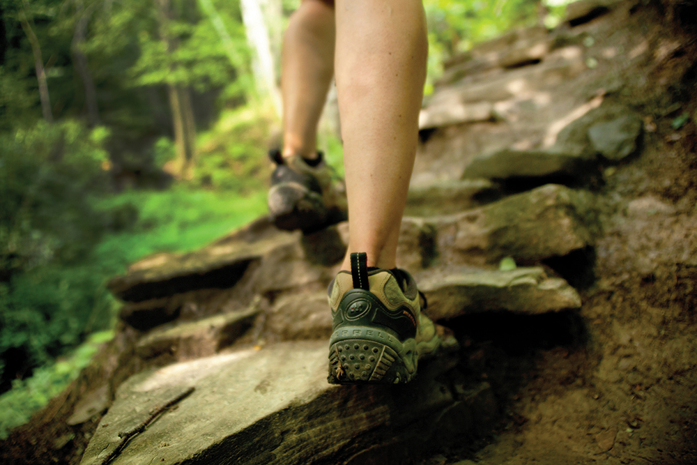
About two kilometres into the hike, we start uphill along a narrow path that becomes more difficult due to the increasing number of boulders and uneven footing. Before we know it, we are in the midst of a massive boulder field that is framed by an impressive rockface on our right. This geological formation is called a scree – an accumulation of rock debris at the base of a cliff.
Leslie Piercey, a retired biologist/ecologist from Meaford, climbs over to the Escarpment cliff face to size it up. “Look at the height of this! It’s the fracturing of these cliffs over time that create the boulder fields,” she explains. “I think of those processes when I’m at the bottom of a wall or crevice like this, and I’m grateful that the rate of change is very slow.”
The hike at this point is best described as a scramble. There is no well-defined passage here – we must climb over or around the rocks, up small inclines and down, following the trail markings on rock surfaces as best we can. The terrain features small caves and crevices that are clearly home to forest creatures, and when we drop down into a pocket surrounded by boulders, we are hit with a blast of cold air that is at least 10 degrees cooler than the ambient temperature. It’s a natural fridge, and a welcome one on this sweltering day.
Due to its technical nature, it takes us some time to navigate the boulder field. But once through, we are back onto an easier path that leads us to the ruins of a homestead built in 1866 by Scottish immigrant John Wilson, whose family farmed the land for three generations. According to a historical plaque at the site, the family cleared the 200-acre plot of land of its boulders and dense forest using only oxen and horses.
The first evidence we see of the Wilson farm is a well-preserved 20-foot well that was dug by hand and lined with stones all the way to the bottom. A short distance away is the stone foundation of a barn that was huge for its time, measuring 92 feet by 62 feet. Some rusty farm implements are scattered here and there.
“I love that some of the equipment is still here, and to think that someone built the barn wall from scratch is incredible,” says Shanna Reid, an outdoor enthusiast who works in the recreation field in Port Elgin. “A lot of work was put into it with little technology and the foundation was very large. They even used some of the natural rock walls as part of the foundation.”
Just beyond the homestead, we came across another historical site: the preserved wreckage of a Cessna 205 that went down in a severe thunderstorm on September 26, 1970. All four aboard perished, and looking at the remains of the plane, I am struck by how fragile this aircraft would have been in a storm.
We continue on our trek, an ascent up the Escarpment that gets our heart rates up. Once at the top, the terrain flattens out, but the trees do their best to obscure the view. There are glimpses of the valley below from our rock ledge, but we have to be mindful of our footing.
We decide that rather than do a loop for our descent, we will come back down through the boulder fields. It’s a smart decision, as it provides a whole new perspective of the scree as we come at it from above. “I think the boulder area is most impressive this way,” says Piercey. “It’s really quite magical. And it’s nice that it’s so wonderfully lush and cool on a hot summer day.”
Once through the boulder field, it’s an easy retrace of our steps back to our parked cars. On this hot, humid day, we’ve covered 7.2 kilometres in a leisurely 2.5 hours.
We’ve done three spectacular hikes, all offering a very different experience of the historic Bruce Trail. Our mission is complete, but it whets our appetites for more. ❧
Blue Mountain
For those looking for a more structured kind of hiking experience, Blue Mountain Resort may be the place to explore.
The resort has significantly expanded its trail system this year, now operating 22 trails or loops that vary in length and difficulty, from challenging ascents up the popular Cascade Trail or The Grind, to easier routes like the Woodview Trail that runs along the top of the Escarpment and is fully accessible.
“We’ve got trails for everyone,” says Tara Lovell, the resort’s manager of public relations. “There are some advanced trails you can go on and some advanced loops that are a little more of a physical challenge. Or, if you just want to explore a little bit, there are trails that are beginner loops for smaller children, or for people who have a stroller or a wheelchair with them.”
This year, Blue Mountain has faced some controversy for a decision to charge for access to its trail network.
One reason is the need to control the number of people on the trails this year due to the COVID 19 pandemic, says Lovell. Another is the fact that the resort invests significantly in the maintenance and supervision of their trail system to ensure it offers a safe environment for visiting hikers. They even have first aid patrollers available should someone require medical assistance. “Charging for hiking was going to happen at some point anyway because it is so popular and because the wear and tear [of the trails] continues,” says Lovell. “But the urgency in implementing it this year is because of capacity management.”
Visitors are able to access the hiking trails and the gondola through a Play-All-Day Pass, a 2021 5×7 or Ikon Season Pass, an Explore Pass, or a Play-As-You-Go Base Camp Attraction Ticket. All of these can be purchased online.
Due to the popularity of the resort’s hiking trails, visitors are strongly encouraged to pre-book their visit so that they are guaranteed access to the trails and gondola on the day they want to hike. “It’s kind of an easy way for people to get into nature,” says Lovell. “It’s an activity that really all you need is a set of hiking boots or even running shoes and the desire to get outside. But go online first, have a look at what we have to offer, and we strongly encourage you to pre-book.” ❧